

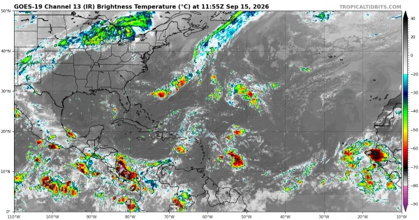
For the first time in the satellite era, the Atlantic Ocean has produced no hurricanes by mid-September, according to the National Oceanic and Atmospheric Administration. The 2026 Atlantic hurricane season has generated five named tropical storms—Arthur, Bertha, Cristobal, Dolly, and Edouard—but not a single one has strengthened into a hurricane. The season's climatological peak date of September 10 passed without a hurricane forming, a milestone that has no precedent since continuous satellite monitoring began in 1966.
The previous satellite-era record for the latest first hurricane belonged to 2002 and 2013, when the first hurricanes formed on September 11 in both years. According to Colorado State University hurricane researcher Phil Klotzbach, only two years in the entire historical record featured zero hurricanes for an entire season: 1907 and 1914. But those years predate satellite technology, meaning some storms could have been missed.
Meteorologists attribute this historic quiet almost entirely to one factor: an exceptionally strong El Niño. "I would say the extremely quiet start is almost 100 percent due to El Niño," Klotzbach said. El Niño is a climate pattern marked by unusually warm sea surface temperatures in the equatorial Pacific. It strengthens upper-level winds over the Caribbean and tropical Atlantic, generating powerful vertical wind shear—the change in wind speed and direction with altitude. That shear acts like an atmospheric shredder, tearing apart developing storm clouds before they can organize and intensify.

This year's El Niño ranks among the strongest on record. According to NOAA data, vertical wind shear in the western Atlantic has broken observation records consecutively. The 30-day average shear strength is the highest since the global satellite era began in 1979, exceeding any prior year by more than 3 knots. "We keep breaking records for vertical wind shear in the western Atlantic," Klotzbach said. "Shear is running well above average across the entire main development region."
A second culprit is Saharan dust. Vast plumes of dry, dusty air from the African desert drift across the Atlantic, injecting dry and stable air into the tropical Atlantic and further stifling the moisture storms need to develop. Jordan Jones, an assistant professor of meteorology at Penn State University, described the combination as a "double whammy."
The Accumulated Cyclone Energy index, which measures overall hurricane season activity, currently stands at just 4.4—the lowest value for this point in the year since the index began in 1950. Four of the season's five storms lasted less than two days.
Why This Matters
The hurricane drought is unfolding against a seemingly contradictory backdrop. Atlantic sea surface temperatures have remained unusually warm in recent years, and warm water is the essential fuel for hurricanes. As AccuWeather chief hurricane forecaster Alex DaSilva put it, the absence of hurricanes despite such warm waters "is truly surprising." The situation underscores just how powerfully El Niño can reshape global weather patterns—enough to shut down an entire hurricane season over exceptionally warm ocean water.
Yet experts repeatedly warn that a quiet season does not mean zero risk. NOAA meteorologist Matthew Rosencrans notes that during El Niño years, the Gulf of Mexico and the U.S. East Coast actually become relatively favored regions for tropical storm and hurricane formation. Hurricanes that do form in El Niño years often intensify rapidly as they approach land, leaving coastal residents with shorter warning times. Hurricane Andrew in 1992 exploded near southern Florida during an otherwise quiet year, leaving roughly 50,000 people homeless.
DaSilva said the odds of a full season with zero hurricanes remain low but cannot be ruled out. Given the unusually warm ocean temperatures, he noted, "if we went the entire season without a single hurricane, that would really demonstrate El Niño's grip on global weather patterns."
The hurricane season runs through November 30. NOAA's National Hurricane Center is monitoring a low-pressure area in the central subtropical Atlantic east of Bermuda, while AccuWeather is tracking a potential development zone near the Gulf of Mexico and the southeastern U.S. coast.